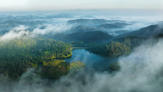
Visitors to Lang Son, in addition to visiting the Mau Son tourist area, can also explore the home village of Loc Binh district, the cool green forest of Van Quan district…

The mountainous province of Lang Son is located in the northeast of Vietnam, about 155 km from Hanoi. Nature has endowed Lang Son with natural mountains and beautiful scenery with a cool summer climate, ideal excursions for tourists.
Author 8X Bui Vinh Thuan (often called Thuan Bui), a native of Lang Son, is a photography enthusiast. Through the series of photos, he shared his desire to promote the colorful scenery of his homeland of Lang to domestic and foreign tourists. In the photo, Lang Son city looks like a bow from above, with the Mai Pha road bridge and parallel railway crossing the Ky Cung river winding through the city center.

Bac Son is not only famous for Na Lay mountain peak, Quynh Son cultural tourism village but also Tam Canh pass, Tam Hoa lake (pictured) in Hung Vu commune. This is a freshwater lake surrounded by high mountains and green trees. On cloudy days, it creates a fanciful scene.

Referring to the historical sites in Lang Son, it is impossible not to visit Chi Lang pass, Chi Lang district. This area stretches for about 20 km, the attractions are concentrated mainly in Chi Lang and Quang Lang communes. On the photo is a mountainside planted with custard-apple in Than Muoi village, Quang Lang commune – a part of Luyai Chi Lang. Na is a specialty of Lang Son, about two weeks from now it will start to harvest na on the mountain.

Mau Son mountain tourist area stretches over 3 communes, including Cong Son, Mau Son of Cao Loc district and Mau Son of Loc Binh district. Mau Son is likened to the “second Sapa” of Vietnam, attractive by its majestic unspoiled natural scenery, diverse and rich ecosystems. Starting from Lang Son city, go 15 km, turn along Highway 4B towards Lang Son – Loc Binh to Mau Son junction, then conquer the arduous 15 km long mountain road with continuous twists and turns. .

One of the unique traditional cultural features when experiencing tourism in Loc Binh district is the home village of the Nung (mainly ethnic group (Nung Phan Slinh) in Tu Doan commune, way from the Chi Ma border gate, bordering the border. China is about 20 km. These houses are made of clay, the walls are 50-70 cm thick, strong, keep warm in winter, cool in summer.In recent years, these houses have attracted many tourists. , photographers come to visit, compose and take pictures.

The community eco-tourism village of Huu Lien commune, Huu Lung district is located in the southwest of Lang Son province, surrounded by limestone mountains, in the middle are lowland forests and valleys of fields. In the ripe rice season, the view of the village from above is picturesque.

Trang Dinh district is located about 67 km from Lang Son city along National Highway 4A, has potential for ecotourism development, fertile and fertile land favorable for agricultural development. For a long time, Trang Dinh has been known as the land of “white rice with clear water”, with the field of Dai Dong commune being a large granary of the province, famous for its sticky rice variety that is both fragrant and flexible.

If visitors experience the mountains and hills of Mau Son, Cao Loc district in the spring, they will be released into the pink color of wild peach flowers. Mr. Thuan Bui said late bloomers covered the mountains and hills in the last days of March in the solar calendar, including ancient forest peach trees over 20 years old with big roots and moss-covered trunks. Dotted between the flower forest is the Dao Lu Gang ethnic group in colorful costumes, creating a spring scene that attracts visitors.

The daily life of the Dao Lu Gang people in the Mau Son mountain area, Cong Son commune, Cao Loc district. This land has 3 ethnic groups living together: Dao, Tay, Nung, in which Dao ethnic group accounts for over 98% of the population. From the past to the present, the Dao people in Mau Son commune, a border zone III commune, have always kept their cultural identity. The Dao people live mainly by farming, raising cattle, embroidering, weaving and sewing traditional costumes. “The unforgettable experience for me to come to this place of taking this photo was to move through a small, craggy dirt road, one side is a cliff, one side is a hillside, through bamboo and anise forests, each house has its own time. separated by a hill,” said Thuan Bui.

Majestic hilly scenery along Tuan Bien road in Bac Xa commune, Dinh Lap district. Bac Xa is still wild and natural, with a border with China of more than 33 km long. This place has many border landmarks to conquer such as landmarks 1297, 1300 and admire the beautiful reed season in October-December every year.

The lush green currant forest belongs to Phai Pha village, Trang Cac commune, Van Quan district. This place is not known by many tourists.

Mr. Thuan Bui shared that to Van Quan district, he could explore Ban Nang lake, Ban Nang village, Tan Doan commune, about 7 km from the commune center. The lake has an area of over 14 hectares, is a natural lake with clear blue water all year round. The landscape of the lake area is beautiful and unspoiled, surrounded by immense aniseed forests, with great potential to exploit for the development of various types of eco-tourism and resort. “Having the opportunity to invite tourists to visit Lang Son, the scenery is spectacular, ravishing and the people are hospitable”, Mr. Thuan Bui confided.
Photo: Bui Vinh Thuan
