GIA LAI – As the “roof” of Gia Lai province, the Kon Ka Kinh mountain peak belongs to the group of ASEAN Heritage Parks with high biodiversity, located in the core zone of the Kon Ha Nung World Biosphere Reserve.

Kon Ka Kinh National Park covers an area of more than 42,000 hectares, located in the northeast of Gia Lai province, 50 km from Pleiku city, distributed in 5 communes: Dak Roong, Kroong, Kron Pne, K’Bang district; Ha Dong, Dak Doa district; Ayun, Mang Yang District.
Kon Ka Kinh, 1,748 m high, is the highest mountain on the Pleiku plateau and is known as the “roof” of Gia Lai province.

The National Park has the following main forest types: lowland subtropical humid evergreen closed forest; lowland subtropical humid coniferous broad-leaved mixed closed forest – the type of forest found only in Kon Ka Kinh in the special-use forest system of Vietnam; tropical moist evergreen forest (small area); secondary subtypes of the agent (poor evergreen broad-leaved closed forest, restored evergreen closed forest, le, cork forest, plantation forest, bare land, grassland…).

Gray-shanked douc or douc langur, scientific name Pygathrix cinerea, is endemic to Vietnam, distributed in the central Truong Son area, in five provinces of Quang Nam, Quang Ngai, Binh Dinh, Kon Tum and Gia. Lai, Vietnam. The population of the population is estimated at 550-700 individuals.
In 2016, Fauna & Flora International – Program in Vietnam announced the discovery of a population of 500 gray-shanked doucans in the Central Highlands of Vietnam and brought the total number of these species to 1000.

Kon Ka Kinh is influenced by the highland monsoon tropical climate. The rainy season lasts from May to November, the dry season lasts from December to April next year. The average annual temperature is from 21 degrees Celsius to 25 degrees Celsius.
Kon Ka Kinh peak area is affected by the law of temperature reduction according to the high belt, so the temperature is below 15 degrees Celsius. The total average annual rainfall varies from 2,000 to 2,500 mm. The average annual humidity is 80%.

Brown-headed lemongrass, scientific name Halcyon smyrnensis, a species of bird in the lemongrass family. This species is widely distributed in Eurasia, east across South Asia to the Philippines.
In most of its range, it is a sedentary species, although many populations are short-distance migratory. It is found far from water where there is much prey including small reptiles, amphibians, crabs, small rodents, and even other birds.
7 species of birds such as (black-headed babbler, long-billed babbler, Kon Ka Kinh babbler, newly discovered for science within the last 30 years in Asia, gray-headed babbler, yellow-billed babbler, pheasant striped and red-ass pagoda).

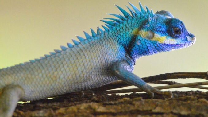
The hedgehog, scientific name Calotes versicolor , is a species of lizard found widely distributed in Asia. It is also introduced in many other parts of the world.
Kon Ka Kinh National Park has 428 species of animals, of which 42 species of mammals, 130 species of birds (belonging to 11 orders, 34 families), 51 species of reptiles – amphibians; 205 species of butterflies belonging to 10 families in the order fins.

Civet, scientific name Viverricula indica , a species of civet family, found in Southeast Asia. They are terrestrial creatures and mainly live in grassy or low shrub areas such as stream slopes.

Falls 95 over 45 m high is the largest and most beautiful waterfall in the National Park. In addition, there is Nang Tien waterfall, a Three-storey waterfall…

The forest protection force went to the field, measured and determined the boundaries of the national park.
Mr. Ngo Van Thang, Deputy Director in charge of Kon Ka Kinh National Park said that the main source of income is salary. The job is high pressure, working alternately day and night regardless of rain and storm to protect the forest… while the salary and allowances are low, there are no job incentives or toxic allowances… set many difficulties. “Many officials can’t stand the pressure to resign,” Thang said.

Kon Bong village, Dak Rong commune, K’bang district is located in the buffer zone of the National Park. Ba Na people mainly grow wet rice, raise livestock and participate in forest protection. People in 18 villages and villages in the buffer zone in K’bang, Dak Doa, and Mang Yang districts have contracted 17,950 hectares of forest.
Kon Ka Kinh National Park currently has 9 forest management and protection stations scattered at the gateway to the forest. Follow vnexpress
Photo: Nguyen Ai Tam
