

Lao Cai province is one of the few localities in the northern mountainous region of Vietnam whose topography is divided into different highlands and lowlands. The mountainous area is majestic and dangerous, concentrated in the North of the province, including districts of Bat Xat, Muong Khuong, Bac Ha, Si Ma Cai, and Sa Pa town.
The medium mountainous areas are concentrated in the South and the South West of the province, including the districts of Bao Yen, Bao Thang, Van Ban; Lao Cai city is located in the North of the province.
Lao Cai mountains coincide with the same message, where there are many highest mountains in Vietnam and the Northwest, mainly located on the Hoang Lien Son range. According to scientists, the Hoang Lien Son mountain range is 30 km wide, 180 km long running in the Northwest – Southeast direction, between the two provinces of Lao Cai and Lai Chau, extending to the West of Yen Bai province.
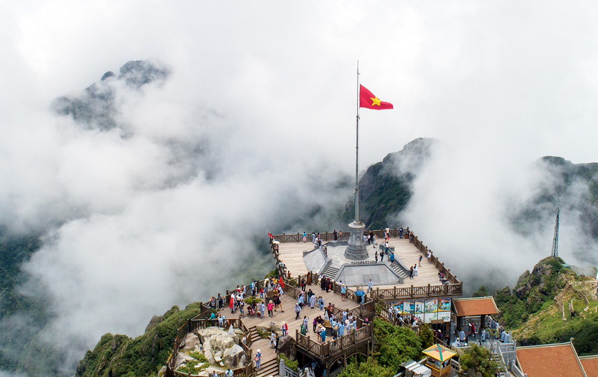
Tourists conquer the top of Phan Si Pang.
Lao Cai province is the only place in our country with many high peaks of over 2,800 m, the most famous of which is Phan Si Pang, 3,143 m high, dubbed the “roof of Vietnam” and “roof of Indochina”. .
Many tourists have successfully trekking to conquer the top of Phan Si Pang mountain and especially in October 2010, the flag of the Great celebration of 1,000 years of Thang Long – Hanoi together with the Fatherland flag flew on the “roof. Vietnamese house ”.
Next is the top of Ngu Chi Son mountain, 3,090 m high, second highest in Vietnam and this is also one of the most beautiful mountains in the Northwest.
On the Hoang Lien range, there are other famous peaks such as Pu Luong peak (2,985 m), Lung Cung peak (2,913 m), Xi Gio Pao peak (2,876 m), Sa Phinh peak ((2,817 m) …
The eastern land of Lao Cai province also has a majestic Tay Con Linh mountain range from Ha Giang province reaching Bac Ha – Si Ma Cai creating mountain peaks like Ta Cu Ty (1,856 m), Quan Than San (1,800 m). , The Lord’s House (1,638 m) …
Especially in the town of Bac Ha district, there are Ba Me Con mountain, Co Tien mountain, creating a charming landscape for this famous tourist area associated with the mountain formation.
The Con Voi mountain range is one of the major mountains in the Northeastern region of Vietnam, separating the Red River from the Chay River that flows through Lao Cai province.
According to scientific documents, this mountain range is over 1,000 m high, 200 km long, 10 km wide. Con Voi Mountain is the last part of the Red River shear zone that runs from Yunnan province (China) to the Northeast of Vietnam.
Hoang Lien mountain range and Con Voi mountain range run parallel to the romantic Red river and Chay river and is the residence for many ethnic groups in Lao Cai and Yen Bai provinces. Each mountain has thrilling and fascinating stories that evoke exploration and discovery for domestic and foreign tourists.
Lao Cai mountains and forests in particular and the Northwest in general create beautiful landscape pictures every morning or when the afternoon falls. It is a unique “tourism product” in the northern highlands of Vietnam that attracts tourists and artists to explore and create literary and artistic works for life.
Source: Lao Cai online newspaper