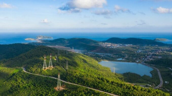
Visitors to Ha Tinh can visit Ke Go lake, Huong Tich pagoda, watch fishing nets or admire the scenery in Nam Gioi mountain.

Ke Go Lake is a famous work in Ha Tinh, designed by the French and built some of the first items. The artificial lake is nearly 30 km long with a capacity of more than 300 million m3 of water, in Cam My commune, Cam Xuyen district, located on the basin of the Rao Cai river, receiving water from hundreds of streams of the Truong Son mountain range.
The photo is part of the series “Beauty of Ha Tinh land” taken by photographer Nguyen Thanh Hai. He was born in 1971, currently lives and works in Ha Tinh city, although he is a businessman, he has a passion for photography. In 2017, he started taking pictures of landscapes, everyday life and traveled to many regions to collect precious photos, currently a member of the Vietnam Association of Photographic Artists.

Not long after starting to shoot, Mr. Thanh Hai has had many winning works such as “A glimpse of Ke Go Lake” which won the first prize of the Ha Tinh tourism beauty photo contest 2018.
Photo of the bridge leading to the island, where there is a shrine to the late General Secretary Le Duan on the bed of Ke Go lake. Le Duan Temple was built in 2011 and completed three years later, attracting many locals and tourists to visit and burn incense.

Ngang Pass (natural boundary of Ha Tinh – Quang Binh) is the narrowest place in our country from the Vietnam – Laos border to the East Sea. In the photo is a part of the Ngang pass crossing the Hoanh Son range, in Ky Anh town with majestic mountains.

Ha Tinh has more than 70 national monuments and 320 provincial relics, many festivals associated with religious activities, where communal houses, temples, pagodas and shrines worship gods, Buddhas and heroes of the people. ethnicity.
Hoanh Son Quan relic, called in Chinese characters, is the gate at Hoanh Son mountain, built-in 1833, during the reign of King Minh Mang controlling the passage of the pass. The locals call this place “Heaven’s Gate” – the highest point of this land. The work was recognized as a provincial historical and cultural relic in 2005.

Referring to Ha Tinh, we must mention Huong Tich pagoda in Thien Loc commune, Can Loc district. The pagoda is located at an altitude of 650 m, halfway on the top of Huong Tich, one of the big mountains in the Hong Linh range, which people often call 99 Hong mountains (or Ngan Hong).
People also call this pagoda Thom, worshiping Quan Am Bodhisattva. The temple is quiet but every year more than ten thousand people visit, the most crowded in January, February and the full moon day of July.

The legendary land of Can Loc is associated with the Dong Loc T-junction, famous for the graves of 10 young female volunteers (from the 4th Battalion, 552nd Company, 55th Battalion) buried by bombs during the war. This junction belongs to Dong Loc commune, located on Ho Chi Minh road, is the intersection of National Highway 15A and provincial road 2, passing through Ha Tinh.

The two lines of Ngan Sau – Thousand Pho originate from the Great Thousand and then confluence at Tam Soa Wharf, forming the poetic La River down to the east.
Tam Soa Wharf is not only a tourist attraction but also a place to exchange goods of the river region. Near the wharf is Quan Hoi mountain, the resting place of the late General Secretary Tran Phu.

The great poet Nguyen Du (1765-1820) was born in Tien Dien, Nghi Xuan, Ha Tinh. In the photo is the memorial area for great poet Nguyen Du with an area of over 4 hectares, storing more than 1,000 precious documents and artifacts related to his life and career. This is a special national relic, each year welcoming tens of thousands of domestic and international tourists to visit.

Cua Hoi Bridge (also known as Ben Thuy Bridge 3) is more than 1.7 km long, is the third bridge across the Lam River, connecting Nghi Xuan, Ha Tinh and Cua Lo, Nghe An. Inaugurated in May 2020, this is a project to promote dynamic economic development in the North Central region.

Nam Nam mountain range is shaped like a boat lying upside down running from the mainland to the sea like a barrier, creating a peninsula in front of Cua Sot. This is an estuary 700 m wide, in Thach Ha district, Ha Tinh province. Nam Nam Mountain not only has plants, animals, caves but also ancient temples, attracting eco-tourism, spiritual culture.

Nature endowed Ha Tinh with a coastline of 137 km, from Cua Hoi, Nghi Xuan to Tam Ky and Ky Anh, so there are abundant marine resources, creating livelihoods for people. The photo above is titled “Chorus of the Sea”, Mr. Thanh Hai captures the scene of fishermen pulling their nets in Loc Ha beach. The work won the international gold medal in Canada 2019, and entered the top 100 drone photos at the 35 Awards contest 2020.

The production process of Cu Do candy, a specialty of Ha Tinh, has been granted a certificate of registration of an exclusive trademark by the National Office of Intellectual Property, Ministry of Science and Technology of “Ha Tinh Cu de Ha Tinh” from June 2019.
“The Ha Tinh photo series is where I keep my views on the land I live in, I’m so proud of my hometown and share it with everyone,” said Mr. Thanh Hai.
Currently, Ha Tinh is identified as a level 2 epidemic risk, corresponding to the yellow zone. People from outside the province entering Ha Tinh for tourism must have 2 vaccinations or one injection must have a negative test certificate within 72 hours, make a medical declaration and perform 5K. Follow vnexpress
