

Mat Than Mountain (Thach Mountain) is now one of the enchanting destinations for all travelers coming to Cao Bang. This place is favorably called by tourists by the name ‘absolute cup’. Not only locals but also tourists who want to visit Ban Gioc Waterfall also want to visit here to see this strangely named mountain. So what is interesting about Mat Than mountain?
Cao Bang is beautiful because there is Mat Than mountain
Where is god eye mountain?
“Eye of God” mountain – Nam Tra waterfall is located in the valley of Ban Danh hamlet, Quoc Toan commune (Tra Linh), about 2 km from the scenic province of Ho Thang Hen province, with majestic and wild beauty. Newly discovered but has attracted many visitors to visit and explore. Non-country Cao Bang
From the provincial road, turn right to Thang Hen lake to Ban Danh hamlet, continue to turn into a trail at the foot of the mountain, you can only walk in, about 1.5 km to reach “Eye of God” mountain – Nam Tra waterfall.
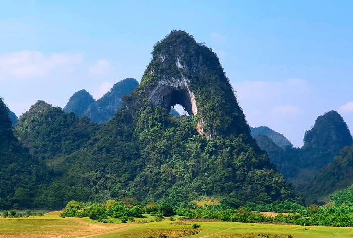
From the top of the mountain, you will be overwhelmed by the view of the 15-hectare Nam Tra lake, empty of water, a vast green grass surrounded by mountains. Under the mountain are winding corn fields that create a “charming mountain water” beauty. The most special is Phja Piót mountain (Tay language: “perfected mountain”), because the mountain has a large space through the round back like an eye, which is often called and praised by tourists with the name of the mountain. Eye of God .
 Beautiful scenery.
The name of the mountain
According to the native Tay people’s voice, Mat Than Nui has the local name “Phja Piót”, which translates to a mountain with a hole, pierced through as if the wind blew from one side to the other. Official documents, has been the leading expert of the Institute of Geology and Minerals of Vietnam (Ministry of Environment and Natural Resources), as well as international experts leading network of geoparks global competence The eye of Than Nui is actually a circular hole with a diameter of more than 50m, located at an altitude of about 50m above the lake surface (Thang Hen).
The cave is located at the present height due to the lifting movement during the Tan tectonic period. The cave develops in a tower-like limestone terrain at a general height of about 650-700m, consisting of tower-shaped and conical blocks interwoven with dozens of large and small lakes, creating the system of Thang Hen Lake ”.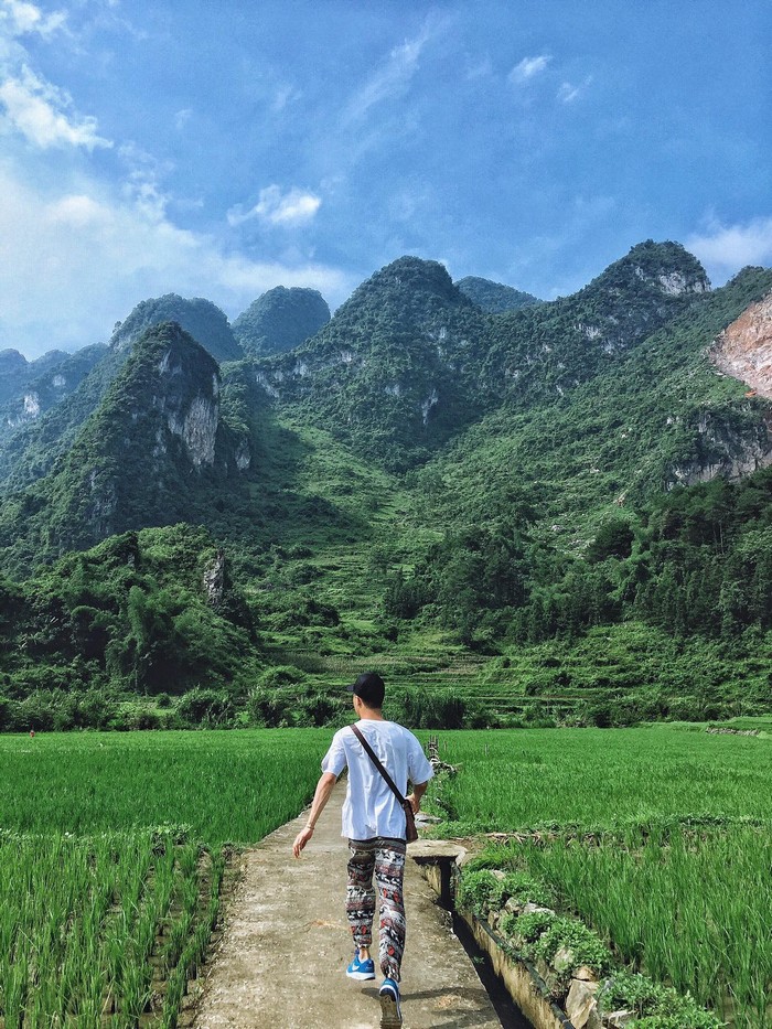 The Eye of the Mountain Spirit has the local name “Phja Piót”, which translates to a mountain with a hole in it
Thung mountain proudly stood and watched the lakes dry season, gradually drying out to reveal the smooth grassy plains. The lakes don’t disappear, they just get tiny and so they are much greener. The restless blue eyes became more silent and deep. The main lake of the three-dimensional hexagonal connection was written by someone three giant letters on the cliff shading in the blue: Quan Tu Mountain.
The unique feature of the Thang Hen lake system is the lakes connected with each other and with surface currents or underground currents. So the water levels in lakes can change seasonally, sometimes very suddenly. Visiting Mat Than mountain in the rainy season (June-August), after going all the way, visitors will not help be surprised to see the lake about 15ha wide named Nam Tra. But during the dry season (from September on), it is also here that local people can graze cattle in the pastures. On the right side, about 500-600m from the lake, a 10-minute walk is Nam Tra waterfall on the stream of the same name, also a beautiful waterfall worth a visit.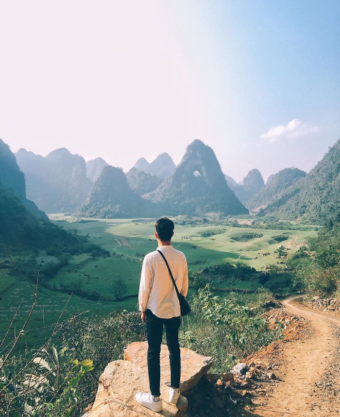 Thach mountain proudly stood up and looked down on the lakes in the dry season
In addition to the unique “Eye of the Mountain”, along the trail only about 15 minutes walk, visitors can enjoy the close harmony, wonderful peace of the Tay people in Ban Danh hamlet, with tiled roofed houses. poplar, rock fence, rice field, corn field, herd of buffaloes, cows … and the surrounding green mature karst landscape, the experience will definitely help you relax after the stress of normal life. day.
How to go to Mat Than mountain
With a diverse karst highland terrain, Cao Bang has mountains and mountains with unique beauty from their altitudes, natural landscapes, unique ecosystems and cultures of each ethnic group and region. Going to the West, you will reach a mountain range of 600-2,000 meters above sea level, typically: Phja Den, Phja Oac (Nguyen Binh) from 800 to 1,900 m, Phja Da (Bao Lac) nearly 2,000 m, Phjng Mon (Bao Lam) over 1,000 m2 … 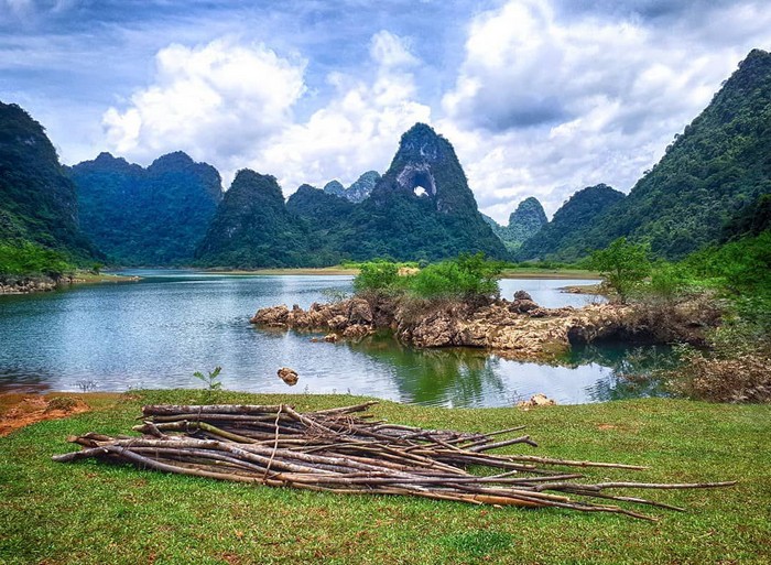 Mat Than Mountain always retains its inherent natural beauty
Coming to these mountains, you seem to reach the sky because you cannot distinguish the distance between the mountains and the clouds. The higher you go, the more clouds fly in layers, rolling, with your hand out you can touch the flying clouds. After each layer of clouds, there is sunshine in long waves running through so you can look down at your feet to see each layer of white clouds floating on top of each other.
Option 1: From the road to Tra Linh district, turn to Quang Vinh – Luu Ngoc commune, about 3 – 4 km further to the section of the mountain. To get here, visitors have to walk another 30 minutes to admire the “Absolutely Cup” area.
Option 2: Walk straight from Thang Hen Lake to about 2 km. The road is more difficult. Note that it can be slippery when it rains, so wear sneakers or boots if it rains. Children should not go this way because it is quite dangerous, easy to stumble, deep lake.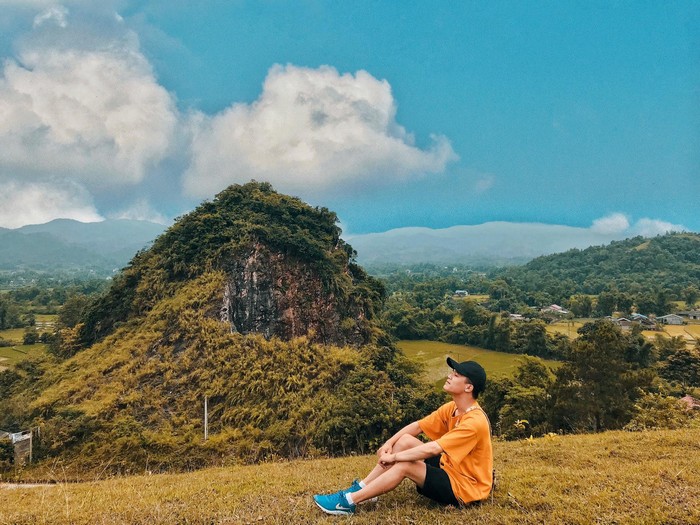 Visitors can come here between September and October
According to the travel experience of Nam Tra perforation mountain in particular and the population of Thang Hen lake in general, visitors can come here in the period from September to October, to witness the miraculous natural phenomenon when the lake water. Thang Hen was drained in just a few hours. If tourists come here during the flood season, the water of Thang Hen Lake still retains its characteristic emerald green color, while other lakes in the region have turned red.
In general, at any time, Mat Than Mountain always retains its inherent natural beauty, making it possible for visitors to come here comfortably all year round, enjoying an enjoyable vacation with family and relatives. However, if you come in the dry season, you will not be able to witness the poetic scenery of Nam Tra waterfall.
Beautiful scenery around Mat Than mountain
In addition to the unique “Eye of the Mountain”, along the trail only about 15 minutes walk, visitors can learn about the daily life of the Tay Cao Bang people, with stilts, stone fences, fields. rice, corn fields, buffaloes, cows … The peaceful and beautiful scenery here makes visitors feel lost in another world, away from the noise and hustle of the city.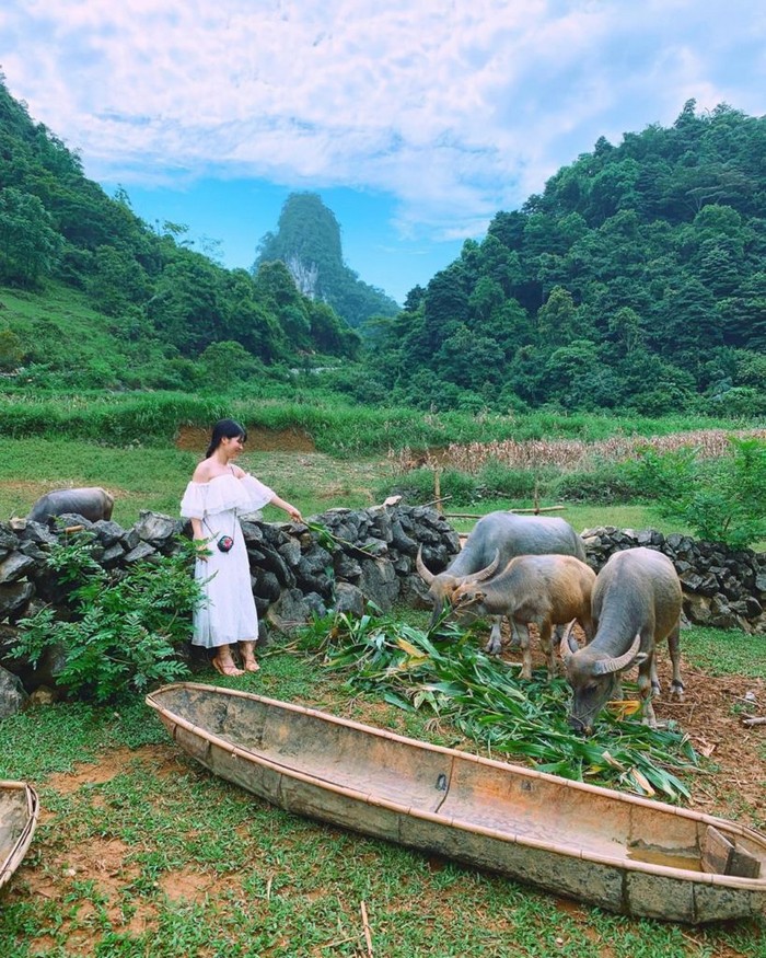 Green steppe around Mat Than mountain
You can enjoy the view of floating clouds and mountains in harmony with the fresh and cool nature. You can also come by Phja Oac National Park with hundreds of species of flora. Explore Mount Phja Da – a mountain that has many changes because when the golden sunlight hits the steep, ivory slippery cliffs, it looks like a giant fire tower, when the rain falls down the cliff like a tower of water from the sky. Down, when the mountain clouds are hidden in white clouds, they don’t know where the mountain is. Come to Phjung Mon (Bao Lam) to watch the clouds floating in the peaceful mountains. Meet and experience the “mountain culture” of rock where the Dao, Mong, Lo Lo people … living quarters. Each village has its own unique culture from stilt architecture space, mountainous cuisine, costumes, rituals …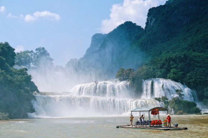 Ban Gioc Waterfall
From Tra Linh district to Chongqing, you will see the pyramid-shaped mountains running in the flat valley on the green Quay Son river. Visit the ancient village of the Tay people in Khuoi Ky with its unique houses. Coming to Thach An district, you come to Bao Dong mountain, nearly 1,000 meters high, visit the relics of the Uncle Ho Observatory that directly led the Border Campaign in 1950. From the top of this high mountain will give you a panoramic view. Northwestern mountainous and forested area, surrounded by conical mountains like giant Buddha hands holding up to meet the clouds and sky. 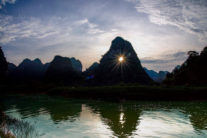 Mat Than Mountain, a symbol of Cao Bang’s grandeur
In the North direction, you will come to the unique high rock mountains in the Luc Khu area, Ha Quang district to explore the space of “rocky mountain culture” of the Mong people. More unique is the stone Cuc in Lung Luong, Keo Yen commune. Scientists identified this as the first stratigraphic fracture point with Ammonite fossils – the name of the group of the highest evolved mollusks, 66 million years ago, representing the site fault. Cao Bang – Tien Yen deep layer, Northwest – Southeast direction, is of international value.
Photo: Internet